EvolvaAI works with Enterprises, Agencies and Generative AI companies
Seeing the World from a New Perspective
AI-powered analysis of aerial and satellite imagery automates the process of identifying objects, tracking changes, and extracting valuable data from vast and complex visual datasets. This technology is revolutionizing how we monitor our planet, manage resources, and respond to events.
Automated Feature Extraction
AI algorithms can automatically identify and classify objects of interest, such as buildings, roads, and vegetation, at scale.
Change Detection & Monitoring
Track changes over time, from urban development and deforestation to the impact of natural disasters.
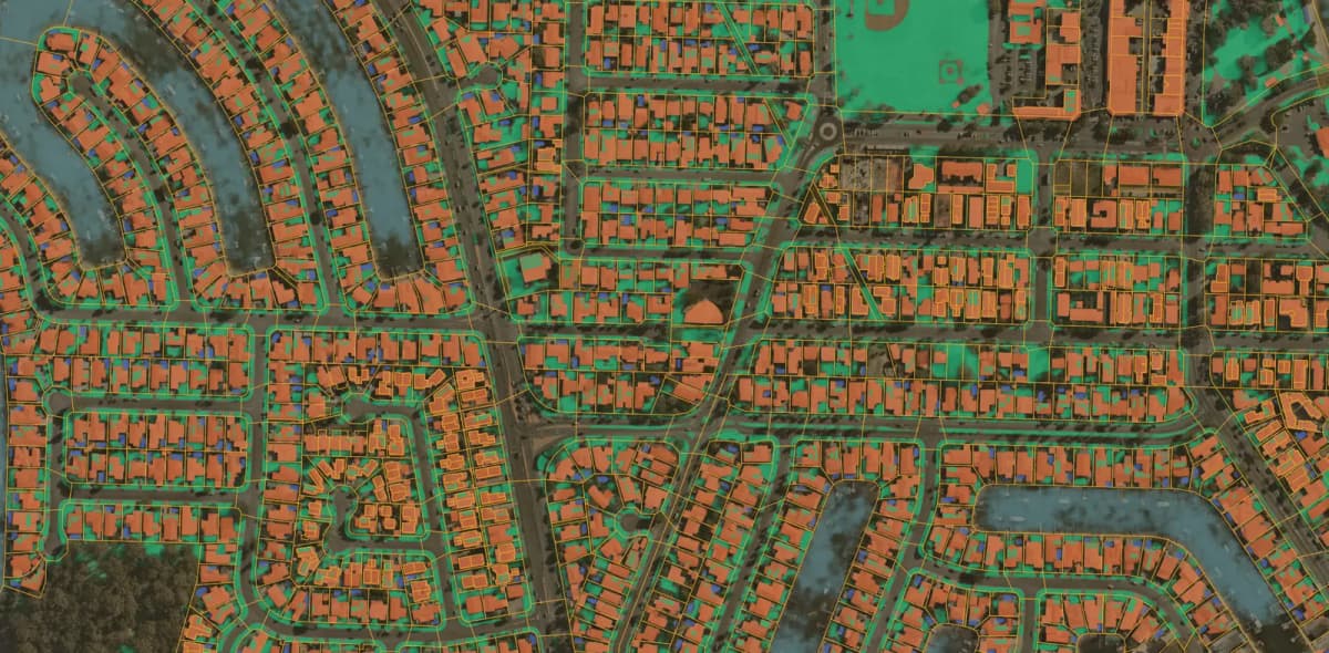
Semantic Segmentation
Go beyond simple object detection to classify every pixel in an image, creating detailed, information-rich maps.

AI-Powered Solutions for Aerial Intelligence
Evolva AI provides a suite of solutions to extract actionable intelligence from any aerial or satellite data source.
Environmental Monitoring
Track deforestation, monitor wildlife habitats, assess wildfire risk, and measure the impact of climate change.
Urban Planning & Smart Cities
Analyze urban growth, monitor infrastructure projects, and optimize city services with up-to-date geospatial data.
Agriculture & Precision Farming
Assess crop health, predict yields, and optimize irrigation and fertilization for sustainable agriculture.
Disaster Response & Management
Rapidly assess damage after natural disasters, identify safe evacuation routes, and coordinate emergency response efforts.
Energy & Utilities
Monitor pipelines and power lines, inspect renewable energy infrastructure like solar farms and wind turbines, and identify potential issues.
Defense & Intelligence
Enhance situational awareness, monitor critical assets, and gather intelligence through automated analysis of satellite imagery.
Driving Geospatial Innovation
Evolva AI empowers organizations to make better, faster, and more data-driven decisions by unlocking the insights hidden within aerial imagery.
Actionable Intelligence at Scale
Process vast areas of imagery in a fraction of the time it would take for manual analysis.
Improved Decision-Making
Gain a deeper understanding of your environment and assets to make more informed strategic and operational decisions.
Increased Operational Efficiency
Automate monitoring and inspection tasks to reduce costs, save time, and allocate resources more effectively.

A Data-Driven Path to Geospatial Excellence
Our structured methodology ensures the successful application of AI to your aerial imagery analysis needs.
1. Objective Definition & Data Sourcing
We work with you to define your goals and identify the best aerial or satellite imagery sources for your needs.
2. Data Preprocessing & Annotation
We prepare and annotate your imagery data to train high-accuracy, custom AI models.
3. Custom Model Development & Training
We develop and train bespoke AI models tailored to your specific object detection, segmentation, or classification tasks.
4. Integration, Analysis & Visualization
We integrate our AI models into your workflows and provide intuitive dashboards and reports to visualize the results.

Pushing the Boundaries of Remote Sensing
Evolva AI is pioneering the next generation of aerial intelligence with cutting-edge research and development.
Multi-Sensor Data Fusion
Combining optical imagery with data from other sensors like LiDAR and SAR to create a more complete and accurate understanding of the world.
3D Reconstruction & Digital Twins
Creating high-fidelity 3D models of cities, infrastructure, and natural landscapes from aerial imagery for immersive visualization and analysis.
Predictive Modeling & Forecasting
Using historical imagery data to forecast future trends, such as urban sprawl, crop yields, or coastal erosion.
On-the-Edge AI Processing
Deploying AI models directly onto drones and other aerial platforms for real-time analysis and decision-making in the field.